Join us in Austin, TX this summer for the ESIP July Meeting! Register today.
Member Highlight: StormCenter Communications, Inc.
Making real-time decisions based on the right information has never been more critical than in today’s fast-past, globalized world. It has also never been more possible, with vast amounts of data and powerful analysis tools at hand. Geospatial data and tools, in particular, enable decision-makers to visualize and analyze complex systems on local and global scales. In order to maximize the decision-making potential of these resources, GeoCollaborateTM, a new geospatial tool, bridges previous gaps and takes geospatial technology to the next level. A user-friendly GIS dashboard, GeoCollaborateTM enables true real-time data sharing and collaboration, even when decision-makers—and their data—are distributed across multiple command center locations. And even when they are using different geospatial viewer technologies.
The Challenge of “Big Data”
In today’s Information Age, data is the key to making informed decisions and analyzing the state of everything from climate change to global markets to national security. But with “Big Data” becoming boundlessly available in vast quantities, our biggest challenge is quickly narrowing in on the right subset of information. And in usable formats that help us solve the challenges at hand. Today, there are a variety of tools for visualizing and analyzing data, including geospatial tools, which provide powerful windows into complex natural and human systems. However, the full power of these tools is often limited by the distributed nature of both the data sets and the scientists, researchers and decision-makers who collaborate to make sense of them. Complex interfaces and the constraints of bandwidth to facilitate virtual collaborations are further limitations to maximizing the real-time decision-making potential of these promising tools. .
Geospatial collaboration technologies in use today are primarily limited to archiving, sharing, and displaying geo-information using geospatial viewers and Common Operating Pictures (COPs). Although these are often described as collaborative in nature, they have no actual real-time collaboration capability. Users must access geospatial datasets from individual computers, retrieving and displaying the datasets individually in order to have access to them and to combine them with their own datasets. If decision-makers are distributed across locations, as is often the case, users typically rely on desktop broadcast technologies such as GoToMeeting®, Adobe Connect® or WebEx®, which can dramatically limit the collaboration experience. Not only is transmission of the broadcasted screen displaying the geospatial viewer subject to bandwidth lag times, but once the meeting has ended all of the data and analysis is no longer shared, additionally hampering follow-up.
Users of geospatial tools, which are increasingly utilized across many industries, have long praised their potential but lamented their shortcomings. In order to maximize its potential, data must be shared in an environment that fosters discussion, ideas, answers, and decision-making among vital subject matter experts. Likewise Geospatial Intelligence needs to mature beyond its current focus of developing data warehouses and identifying which kinds of geospatial viewers and tools are being used, toward a future of true collaborative analysis and effective decision-making.
Taking Geospatial Data Sharing to the Next Level
In answer to this growing need, StormCenter Communications, Inc., a 25-year veteran of the geospatial data world, created GeoCollaborateTM, an innovative geospatial data sharing and collaboration tool developed over the past 5 years through extensive R&D, collaboration, and highly-competitive grants with federal agencies including NASA and NOAA. GeoCollaborateTM was designed specifically to address the limitations and challenges the company and its agency collaborators saw firsthand with leveraging geospatial data. With a goal to make geospatial decision-making a seamless and user-friendly experience for distributed teams and data, StormCenter CEO Dave Jones compares his team’s aspirations to making the “Apple of GIS”—in other words, making the traditionally complex and clunky GIS experience accessible and sleek. GeoCollaborateTM takes geospatial technology to the next level by providing a user-friendly dashboard that enables true real-time data sharing and collaboration, even when decision-makers—and their data—are distributed across multiple command center locations. And even when they are using different geospatial viewer technologies.
StormCenter’s development of GeoCollaborateTM has been informed by a deep understanding of both the geospatial analysis process as well as the realities of real-time, distributed decision-making. In order for data and analysis tools to be optimally effective, they must facilitate true sharing and collaboration in real-time. And they must do so while also bridging a variety of stakeholders—including those with a range of GIS expertise—who may be at multiple locations on a variety of devices with varying connection speeds.
StormCenter set the bar high for itself in defining successful collaboration to only be achieved when all users receive, share, discuss, and even annotate the same data sets in real time, and have access to all the tools and functions offered in the geospatial viewer or COP. In addition, at the end of each collaboration session, each user maintains the full set of shared data visualizations, and annotations created during the collaboration on their own geospatial browser, in their own device, allowing stakeholders to perform further analysis and presentations and to more effectively act upon the data and decisions beyond the session. In addition, this record of the decision tree enables users to go back to analyze key points in the decision-making process as well as to utilize GeoCollaborateTM for training scenarios and demos. With crisis management and response becoming an increasingly complex and time-sensitive coordination of distributed information and stakeholders, the opportunity to have meaningful training sessions within the same tool has become an important added benefit of this new technology.
Connecting with Efficiency
To achieve this collaborative mission, StormCenter. has developed the capability to connect disparate geospatial viewers in real time. A leader engaged in one of these collaborative sessions can control other map viewers, including dynamic zooming in and out, panning, adding data layers, and annotations. This technology can run on stand-alone map viewer applications or as a server based interactive web map application available on local, secure and/or public networks and servers. The solution is designed to scale and take full advantage of modern cloud computing solutions and elastic clouds, which expand the bandwidth necessary on-demand, based on user requirements, with no human intervention. In addition, GeoCollaborateTM data is sent over networks in a much less bandwidth-intensive way than broadcast screen-sharing tools, making it a true real-time experience, even across great distance and for those with less optimal connections. It can survive network outages or slow network connections, so all attendees can ultimately receive and view all the data layers and annotations being shared during the collaboration.
|
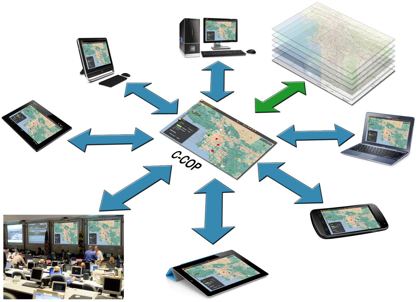
A Collaborative Common Operating Picture, or C-COP, can be used to share Geospatial data among multiple groups, devices and viewer platforms for enhanced decision making |
StormCenter’s collaborative technology has already been used on multiple Commercial Off-The-Shelf (COTS) GIS platforms and web map viewers such as ESRI ArcGIS Desktop, Online JavaScript and Flex viewers), Google Earth and Google Maps, as well as free and open source map viewers, like NASA World Wind, and custom-made viewers. Not only can the collaborative capability be installed on any of these viewers, the technology does not interfere with, alter, or re-serve the geospatial data layers shared and that are currently available from the established authoritative data sources (that publish and update accurate and reliable data on trusted servers). It is fully compatible with OGC standard services, such as WMS, REST, JSON, SOAP, KML / KMZ files, as well as all geospatial services and files compatible with the geospatial viewers used.
How is StormCenter putting this technology to use today?
StormCenter is currently engaged in a pilot project between the National Weather Service Weather Forecast Office (WFO) in Sterling, Virginia, and the Maryland Emergency Management Agency (MEMA). Using a recently awarded down-selected NOAA-wide sole-source IDIQ contract, StormCenter was able to create a Common Operating Picture (COP) for the Sterling WFO to be used collaboratively and in real-time to disseminate and integrate weather data directly into MEMA’s existing geospatial viewer, called OSPREY. OSPREY is the geospatial COP environment which MEMA uses every day for situational awareness. Without having to change MEMA’s existing viewers, install new software, or lose the investment they had already made in OSPREY, StormCenter developed a widget to make their viewer collaborative. The NWS can now use their Emergency Response Meteorologists (ERMETS) to deliver critical NOAA products directly to MEMA with subject matter expertise for briefing and Impact-based Decision Support Services (IDSS) as well as to conduct exercises and showcase and obtain feedback on new products, all in support of creating a Weather Ready Nation (WRN).
|
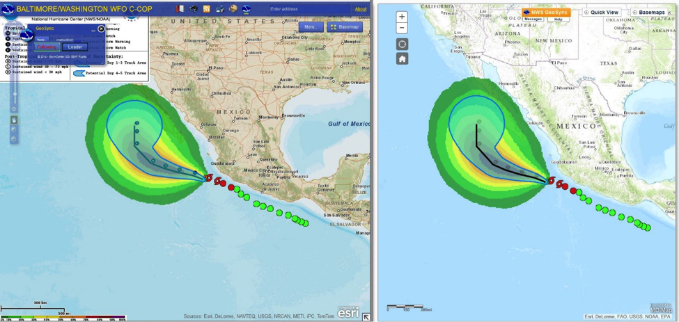
An example of data sharing across platforms during a briefing. On the left: The NWS leads with an ESRI Flex Viewer sharing hurricane data. On the right: MEMA follows on their Javascript GIS Viewer receiving the data from the NWS ERMET. |
StormCenter is working to educate agencies and working groups at the federal and state levels regarding the significant opportunities now available to improve their intelligence and decision-making capabilities by sharing data and collaborating via StormCenter’s unique tools. StormCenter’s real-time collaborative geospatial data sharing technology is a solution that we anticipate will become a core solution to the challenges of geospatial data sharing and collaboration throughout the federal government for scientists, researchers, educators and decision makers. This innovative technology cuts across many mandates for open government data and data dissemination. For more information on the technology and contracting with StormCenter, please contact us:
Link: www.stormcenter.com
Type: III
Joined: 1999
ESIP Voting Rep: Dave Jones
StormCenter Communications, Inc.
bwtech@UMBC Research & Technology Park
1450 S. Rolling Road, Mail Stop 4.029
Halethorpe, MD 21227
410-203-1316
[email protected]
www.stormcenter.com

